


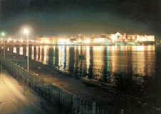
Guardata dal mare Taranto vecchia emana un fascino particolare, sopratutto la sera quando l'illuminazione - voluta dall'Amministrazione Comunale - mette in risalto il profilo della "palazzata" che si affaccia sulla ringhiera. E' così che i tarantini chiamano quella parte del borgo antico un tempo abitata dai nobili e dal clero.
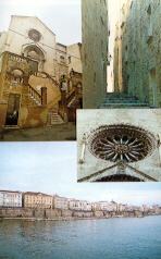
La facciata romanica di San Domenico, l'Arcivescovado, il palazzo D'Ayala Valva si susseguono in un tripudio di stili ed epoche differenti che rispecchiano la movimentata e antica storia della città. Taranto vecchia è arroccata su un'isola che si riallaccia alla città nuova per mezzo di due ponti e, la ringhiera, costituisce una delle sue principali arterie di collegamento. Addentrandosi nel cuore antico della città si scopre la magia di vicoli strettissimi e di luminose piazzette, l'eleganza architettonica di case e strade.
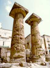
Taranto, Siracusa e Corinto sono le sole città al mondo dove ci siano resti di un tempio greco della prima metà del VI sec. a. C. Del TEMPIO DORICO in piazza Castello si aveva notizia sin dal XVIII secolo, quando le due colonne ora completamente visibili erano inglobate nell'oratorio della SS. Trinità, abbattuto più di 30 anni fa per portarle alla luce. Oggi sono rimaste solo due colonne e la base di una terza, ma il tempio doveva essere lungo circa 50 metri, ed aveva probabilmente 17 colonne da un lato e 6-8 colonne dall'altro. Il tempio venne edificato nel periodo di definitiva affermazione della potenza di Taranto nell'ambito della Magna Grecia di cui fu la capitale. Ma la costruzione del tempio coincide anche con la sistemazione urbanistica di Taranto, con l'Acropoli nella città vecchia e la Polis nel Borgo.
Il tempio Dorico è più noto come tempio di Poseidone, ma è più probabile che fosse dedicato ad una divinità femminile. E' dunque più vicina alla verità la tradizione dello scorso secolo, in cui veniva chiamato tempio di Diana. Nella piazza antistante sorgeva il convento dei Celestini, abbattuto negli anni '20 per far posto ad un ufficio postale. Ma fu impossibile realizzare la costruzione per l'abbondanza di testimonianze archeologiche emerse dal terreno.
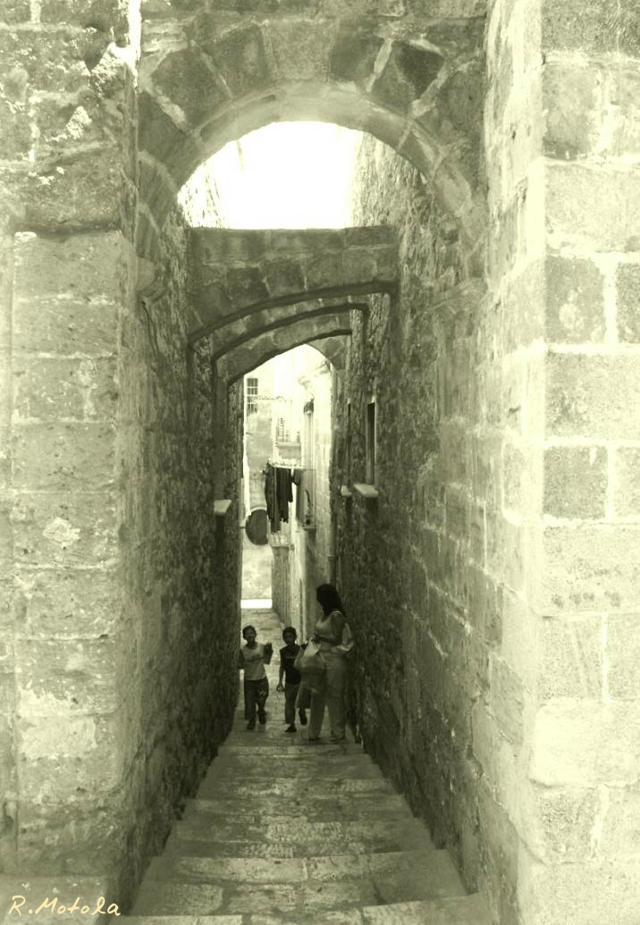
Siamo nella cosiddetta parte "bassa" della città vecchia. Pare che questa zona del centro storico sia da attribuire al programma di ricostru-zione di Taranto voluto nel sec. X da Niceforo Foca. In pratica, l'area dell'antica acropoli (corrispondente approssimativamente alla parte "alta" della città vecchia), venne ampliata verso il Mar Piccolo mediante colmate a mare. LARGO PETINO, dopo le recenti demolizioni di edifici recenti, è uno dei punti dai quali si vede ad occhio nudo il salto di quota, variabile fra i 9 e i 12 metri ma che arriva fino a 20 metri fra Vico Cosa e Arco Cosa.
Nello scorcio di Largo Petino ritratto nella foto, si vedono alcuni ambienti scavati nel banco tufaceo che costituiscono un esempio di architettura in "grotta" (simile a quella delle numerose gravine ioniche), che a Taranto è legata ad un'estesa attività di estrazione di materiale di cava. Non a caso questa zona coincide con la zona restaurata di Via Cava, che segna la linea di demarcazione fra i quartieri della città alta (Pittaggi del Baglio e di San Pietro) e quelli della città bassa (Pittaggi del Ponte e di Torrepenna
English:
Photo n.1
Viewed from the sea old Taranto radiates a special charm especially at night when the lighting – wanted by the municipal administration – highlights the profile of the “palazzata” (facade) that overlooks the railing. It is so that the people of Taranto calls that part of the ancient village once inhabited by the nobles and the clergy.
Photo n.2
The Romanesque facade of St. Dominic, the Archbishop’s Palace, the palace D’Ayala Valva follow each other in a riot of different styles and eras that reflect the vibrant and ancient city’s history. Old Taranto is perched on an island that is linked to the new city by two bridges and the railings, is one of its main thoroughfares. Entering the ancient heart of the city discovers the magic of narrow lanes and luminous squares, the elegant architecture of houses and roads.
Photo n.3
Taranto, Syracuse and Corinth are the only city in the world where there are remains of a greek temple of the first half of the sixth century B.C. Of the Doric temple in Piazza Castello we had news Taranto in Il tempio Dorico è più noto come tempio di Poseidone, ma è più probabile che fosse dedicato ad una divinità femminile. since the eighteenth century, when the two columns now fully visible were incorporated in the oratory of SS. Trinity, demolished more than 30 years ago to bring them to light. Today only two columns and the base of a third have remained, but the temple was to be about 50 meters long, and probably had 17 columns on one side and 6-8 columns on the other. The temple was built during the final affirmation of the power of Taranto in Magna Grecia, of which it was the capital. But the construction of the temple also coincides with the urban layout of Taranto, with the Acropolis in the old town and the Polis in the village.
The Doric temple is best known as the temple of Poseidon, but it is more likely that it was dedicated to a goddess. It is therefore closer to the truth the tradition of the last century, when it was called Temple of Diana. In the opposite square rose the Celestine’s convent, demolished in the ’20 to make way for a Postal Office. But it was impossible to carry out the construction for the abundance of archaeological findings that emerged from the soil.
Photo n.4
We are in the so-called "low" part of the old city. It seems that this area of the historical centre is attributable to the program of reconstruction of Taranto wanted in the X century by Niceforo Foca. In practice, the area of the ancient acropolis (corresponding roughly to the "high" part of the old city), was extended to the Mar Piccolo filling the sea.LARGO PETINO, following the recent demolition of recent buildings, is one of the points from which we see with the naked eye the jump in altitude, ranging from 9 and 12 meters but up to 20 meters between Vico Cosa and Arco Cosa.
In view of Largo Petino in the picture, you can see some spaces excavated in tuff that are an example of architecture in "cave" (similar to that of the many ionic ravines), which is linked to Taranto to extensive mining activities of quarry material. No coincidence that this area coincides with the restored area of Cava Street, which marks the boundary between the districts of the upper town (Pittaggi Baglio and St.Peter) and those of the lower city (Pittaggi Bridge and Torrepenna